

La Niña: What you need to know
- Oct 20, 2020
- 5 min read
A discussion on the La Niña seasonal pattern and its effects.
Written by: Akshaya, Haritha, Kavya

You may have heard about La Niña and El Niño. Here we discuss the general differences between weather and climate, why La Niña occurs, and what are its current effects on our global climate.
What is the difference between weather and climate?
You may be aware that weather and climate are related, but they do not actually contain the same meaning. The term ‘weather’ is used when discussing the day-to-day conditions, whereas climate covers the weather over a certain period of time. When you talk about the weather, you would typically discuss the temperature, humidity, precipitation, wind, and other aspects of atmospheric conditions of the near future (1). Comparatively, climate includes statistical information on the regular weather patterns as well as the range of weather extremes in a particular area (1). As we will discuss later on in this post, there are certain cycles that occur due to climate change and various weather patterns. Discussing climate change means that we are covering the change in the weather in terms of years, and sometimes, even millions of years. In this, scientists examine the trends or ‘cycles of variability,’ which include changes in wind patterns and ocean surface temperatures (1). Cycles such as the ones that occur over the equatorial Pacific which result in La Niña/El Niño are studied to look at the long-term effects and in discussing permanent changes of the climate (1). The local weather affects us daily, but this results from global patterns in the atmosphere which are affected by various types of landscapes, interactions of solar radiation, and more (5). Let’s look more closely at weather and climate patterns and what affects them, specifically.
What controls weather patterns?
Local weather conditions that we experience are affected by air masses and fronts. Air
masses are global wind patterns that control bodies of air. The location of the air mass influences its characteristics, such as being hot and humid or cold and dry (5). Fronts are the places where two air masses meet, which can be seen through weather maps (5). Cold fronts means that a cold air mass is replacing a warm one, and the opposite goes for a warm front (5).
What controls climate patterns?
Climate is affected by the various interacting factors such as latitude and elevation, as
well as nearby water, ocean currents, topography, vegetation, as well as prevailing winds (7). To explain further, different zones of climate are correlated with different elevation ranges, land temperatures are affected by sea surface temperatures, water temperatures show a transfer of heat energy through currents, and winds can deliver air masses with specific properties (7).
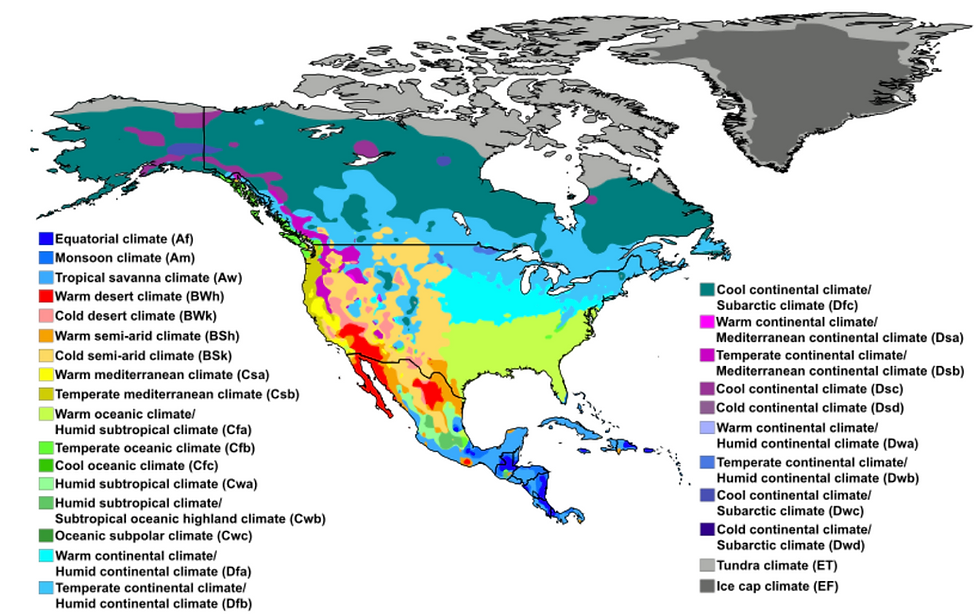
This map shows the various climates that can be observed in differents regions in North America (2).
Some common climate patterns in the world
We see and observe some of the different climate patterns that occur every year and
every few years often. Climate patterns, as we have mentioned, are affected by location and the specific regions which outline the characteristics of the weather, as different parts of the world also receive different amounts of radiation (and during different times of the year) (8). The four seasons we experience are also affected by location, as places near the equator don’t receive huge seasonal changes in temperature, but Northern and Southern Hemispheres have their seasons at opposite times of the year. In January, the lowest temperatures can be observed in the northern continents, whereas in July, these regions experience strong heat from the Sun. The reason that places near the equator are typically cooler than desert areas is due to the fact that the heat energy is used to evaporate the large amounts of precipitation which occurs there (8).
What is La Niña?
La Niña is a climate pattern that occurs every three to seven years, near the tropical Pacific ocean. La Niña in Spanish means ‘little girl’. La Niña is the cool phase where there are noticeable differences in the ocean temperatures, winds, surface pressure and rainfall patterns (3). During La Niña, the winds in the ocean surface of the Pacific become stronger and result in cooler temperatures.
How is it caused and what are its effects?
In the years where La Niña or El Niño do not take place, the warm ocean waters near the equator of the South American region are pushed to the west, near Indonesia. When this happens, the colder deep ocean water rises to the surface (4). During La Niña, the winds are much stronger and result in the ocean water temperatures to be even colder. This means that the regions with warmer water temperatures, such as Indonesia and Australia, will experience heavier-than-usual rainfalls. The regions along colder water temperatures will experience a drier season, such as the southern US (4). This weather pattern is caused by the interaction between the Pacific ocean and the atmosphere (4). As the largest ocean in the world, the slight changes in the ocean water temperature can contribute significantly to the seasonal patterns. More tropical cyclones and hurricanes are observed in the tropical regions as well (4).

Rainfall pattern around the world caused by La Niña (3).
Significance of La Niña on global climate
What can we expect this year?
Computer models predict that this year’s La Niña will continue through the winter and diminish during the spring (6). Sources also say that there is a substantial amount of water in the pacific ocean that is cooler than average (6). This is another reason for the La Niña to continue through the winter. Forecasts have also predicted cold, wet winter conditions in the northern part of the United States whereas warmer, dryer conditions in the southern part (2). Currently, there is drought in several parts of the United States including the western USA and parts of the northeast (2). With La Niña, drought in these areas may be intensified (2). Warmer than normal temperature conditions are expected in the Southern tier of the USA as well as northern Alaska and Hawaii (2).

Expected winter temperatures in North America due to La Niña (4).
Historical examples
There have been several La Niña instances before. The 2010-2011 La Niña incident had a huge impact in Australia (9). 2010 was the third wettest year in Australia’s record and 2011 was the coolest in a decade (9). Ocean temperatures to the north of Australia were the highest ever recorded (9). The La Niña was responsible for severe floods in Australia in 2010. 10,000 people were forced to evacuate and the damage was worth $2 billion (10). The 1988-89 La Niña was additionally estimated to have cost $40 billion in damages in North America (10).
References:
Image References:


Comments